-
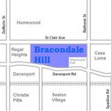
Bracondale Hill
Bracondale Hill, also known as Hillcrest, is a neighbourhood located in Toronto, Ontario, Canada. Annexed by the old City of Toronto in 1909 and developed in 1911 from the Turner estate, Bracondale Hill is in the western end of midtown Toronto and stretches above Davenport Road and below St. Clair Avenue West. The area is […]
Learn More -
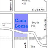
Casa Loma
Casa Loma is a neighbourhood in the city of Toronto in Ontario, Canada, and is named after the famous castle. It is bounded on the north by St. Clair Avenue West, on the east by Spadina Road, on the south by the CP railway tracks, and on the west by Bathurst Street. Transit access is […]
Learn More -
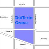
Dufferin Grove
Dufferin Grove is a neighbourhood located in Toronto, Ontario, Canada, west of downtown. The neighbourhood is bordered by Bloor Street West to the north, Ossington Ave to the east, College Street to the south, and Dufferin Street to the west. It is a working class neighbourhood with a large diversity in cultures and to an […]
Learn More -
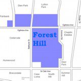
Forest Hill
Forest Hill is an affluent neighborhood in central Toronto, Ontario, Canada. Along with Lawrence Park, Rosedale, and The Bridle Path, it is one of Toronto’s wealthiest neighbourhoods. The neighbourhood’s original boundaries were Bathurst Street to the west, Upper Canada College to the east, Eglinton Avenue to the north, and Lonsdale Road and a portion of […]
Learn More -
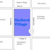
Harbord Village
Harbord Village is a neighbourhood in Toronto, Canada. It lies just to the west of the University of Toronto, with its most commonly accepted borders being Bloor Street on the north, Spadina Avenue on the east, College Street to the south, and Bathurst Street to the west. Areas west of Bathurst, as far as Ossington […]
Learn More -

Humewood-Cedarvale
Humewood-Cedarvale is a neighbourhood in the city of Toronto, Ontario, Canada, historically part of the York borough. The neighbourhood is bordered by Bathurst Street to the east, Eglinton Avenue to the north, Winnett Avenue to the west and St. Clair Avenue to the south. The neighbourhood is often referred to by each distinct name with […]
Learn More -

Kensington Market
Kensington Market is a distinctive multicultural neighbourhood in Downtown Toronto, Ontario, Canada. The Market is an older neighbourhood and one of the city’s most well-known. In November 2006, it was designated a National Historic Site of Canada. Robert Fulford wrote in 1999 that “Kensington today is as much a legend as a district. The (partly) […]
Learn More -
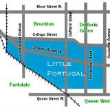
Little Portugal
Little Portugal (also known as Portugal Village) is a neighbourhood and ethnic enclave in Toronto, Ontario, Canada. It is located west of downtown in the “Old” City of Toronto. It is bounded on the west by Lansdowne Avenue, on the north by College Street, on the east by Ossington Avenue and on the south by […]
Learn More -
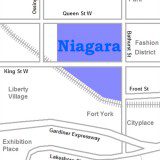
Niagara
Niagara is a neighbourhood in Toronto, Ontario, Canada, located along and south of King Street West; it is usually bordered by Strachan Avenue to the west, Bathurst Street to the east, and the railway corridor to the south, and so named because Niagara Street runs through the centre of it. The eastern portion of this […]
Learn More -
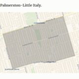
Palmerston–Little Italy
Palmerston–Little Italy is a neighbourhood in central Toronto, Ontario, Canada. Its boundaries, according to the City of Toronto, are by Bathurst Street to the east, Bloor Street to the north, Dovercourt Road to the west and College Street to the south. It is a mature downtown neighbourhood. Within this official neighbourhood of the City of […]
Learn More -
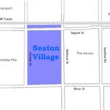
Seaton Village
Seaton Village is located west of downtown Toronto, Ontario, Canada. It is named after John Colborne, 1st Baron Seaton, Lieutenant-Governor of Upper Canada from 1828 to 1836. Seaton Village is bordered by Bloor Street to the south, the Canadian Pacific Railway (C.P.R.) tracks to the north, Christie Street to the west, and Bathurst Street to […]
Learn More -
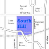
South Hill
South Hill is an area of Toronto, Ontario, Canada. It is located north of downtown covering the area west of Avenue Road, south of St. Clair Avenue, east of Spadina Road, and north of the Canadian Pacific railway tracks. The area is dominated by the steep hill of the former Lake Iroquois shoreline. The Nordheimer […]
Learn More -
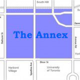
The Annex
The Annex is a neighbourhood in downtown Toronto, Ontario, Canada. The traditional boundaries of the neighbourhood are north to Dupont Street, south to Bloor Street, west to Bathurst Street and east to Avenue Road. The City of Toronto recognizes a broader neighbourhood definition that includes the adjacent Seaton Village and Yorkville areas. Predominantly English-speaking, it […]
Learn More -
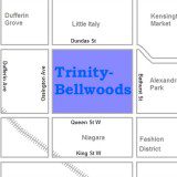
Trinity–Bellwoods
Trinity–Bellwoods is an established inner city neighbourhood in Toronto, Ontario, Canada. It is bounded on the east by Bathurst Street, on the north by College Street, on the south by Queen Street West, and by Dovercourt Road on the west. It has a large Portuguese (mostly originally from the Azores and Madeira islands) and Brazilian […]
Learn More -
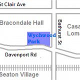
Wychwood Park
Wychwood Park is a neighbourhood enclave and former gated community in Toronto, Canada. The small community is located north of Davenport Road and just west of Bathurst Street. It was founded as an artists colony in the late nineteenth century as a private project by painter Marmaduke Matthews and Alexander Jardin. The region was then […]
Learn More
ABOUT US
By working as a full service team Douglas and Trevor provide their clients with exceptional customer service, unmatched experience and a wealth industry knowledge.
Read MoreNAVIGATION
TOOLS & CALCULATORS
Copyright © 2024 Doug & Trevor Freeman Real Estate
website design & development by